Posts for this topic...
-
Post your comments.... Sign In to Post
-
plotaroute admin Tuesday 09 Mar 2021 16:09:00
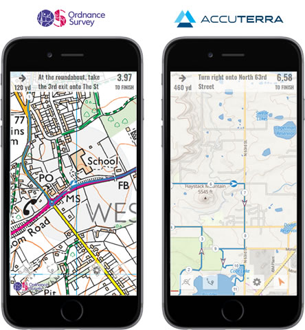
Following our announcement last month about the introduction of Ordnance Survey and AccuTerra maps on the desktop route planner, we're pleased to announce that we've now rolled these maps out to our mobile app and desktop route viewer. The maps are available to Premium members and can be used when plotting or viewing routes in the UK or the US.
We've also upgraded our Locate Map feature in the route planner to accept Ordnance Survey Grid References, so you can now search the map using the standard OS grid reference format e.g. TQ 12345 67890.
Lastly, as part of this release we've tweaked the way that the Map Inspector works on our mobile route planner. Previously this was accessed by tapping the crosshair on the map, but some users were reporting that this was causing it to be triggered accidentally, so we've now changed this to require a double-tap.

For further information about Premium membership, please visit our Membership Options page.
-
Colin Hoppe Wednesday 10 Mar 2021 12:33:15
Having the Ordnance Survey map to view whilst walking is very handy. Now if I need to update the directions - and I can see exactly where I am on the map - the Map Inspector not only tells me the coordinates but also enable copying to the clipboard. Very good !
-
Colin Hoppe Wednesday 10 Mar 2021 12:35:25
Aah - except I can't see the Map Inspector on the mobile app ...
-
plotaroute admin Thursday 11 Mar 2021 08:35:38
The Map Inspector can be accessed on the route planner in the mobile app - double-tap on the crosshair.
-
Colin Hoppe Saturday 13 Mar 2021 12:04:07
Are you sure ? Firstly, there is no crosshair on the Ordnance Survey map on my phone. Secondly, while the other maps have the crosshair, double-tapping on it just zooms in closer ...
Am I missing something ?
-
plotaroute admin Saturday 13 Mar 2021 12:51:09
Thanks Colin, we hadn't spotted that the crosshair was missing on the mobile route planner when using OS maps. The problem was caused by OS maps using a different map projection than all the other maps we use. We've put in an urgent fix for this, so it should be there now. The double-tapping issue is one we'll need to look into next week. This works fine on iPhones but there does seem to be a problem with it on Android devices.
-
plotaroute admin Monday 15 Mar 2021 08:52:15
We've implememted a fix for the problem with accessing the Map Inspector in the route planner on Android devices, so it should be working OK now.
-
Colin Hoppe Monday 15 Mar 2021 10:38:55
OK - the Map Inspector now works when plotting on Ordnance Survey and others on my android phone.
I'm not sure how much I would use the app for walking, so it's best you listen to others' comments on how it is in practice, but something I imagine could be useful was being able to readily copy the coordinates in the Map Inspector, as you can on the desktop version.
However, at the moment, the Map Inspector is only available in plotting mode. If it were available in the View / Interactive mode ie guiding through the route, and I wanted to make a note for next time about how to proceed from a specific location (which might or might not be quite on the plotted route), being able to copy and paste the coordinates to a notepad app would be handy. Then I'd be able to edit the route later ... Or maybe simply mark a point on the map with a number 1 - then mark number 2 etc - and make notes in reference to those numbers (assuming it saved the marks).
Or maybe not. As I say, best to see what other think ...
-
David Tidmarsh Friday 26 Mar 2021 18:49:05
Brilliant John. The addition of the OS maps is a big step forward. From your loyal distance horse traveller in Scotland. I did a 10 day / 200 mile ride round the Cairngorms in 2018 using Plotaroute challenge to share daily including photos. Loosely based on journeys on horse back done by Queen Victoria. I later learn a member of the royal family was following me on Plotaroute! So you have a royal user!
-
plotaroute admin Monday 29 Mar 2021 13:14:15
Thanks for sharing that story David. Good to hear you're still making good use of the site. We appreciate all loyal (and royal) users!
John
