Posts for this topic...
-
Post your comments.... Sign In to Post
-
Kevin Moore Tuesday 28 Apr 2020 14:13:52
What a great idea and I understand your current restrictions. However, it would be a great tool for planning much longer rides such as Audax in the future so I look forard to you developing it further.
-
Colin Jones Sunday 26 Apr 2020 10:14:53
thank you, good idea
-
Dom McIntyre Saturday 25 Apr 2020 10:43:35
That's a great idea!
-
plotaroute admin Friday 24 Apr 2020 17:16:39
The coronavirus crisis has resulted in many restrictions being placed on us, including how and where we exercise. We are being asked to keep our distance from other people and stay close to home when going out for a walk, run or cycle ride. In some countries, people are restricted to going no more than 2km from home. So, to help you plan routes that stay within a restricted area, we have today launched our new Plot a Radius Map tool.
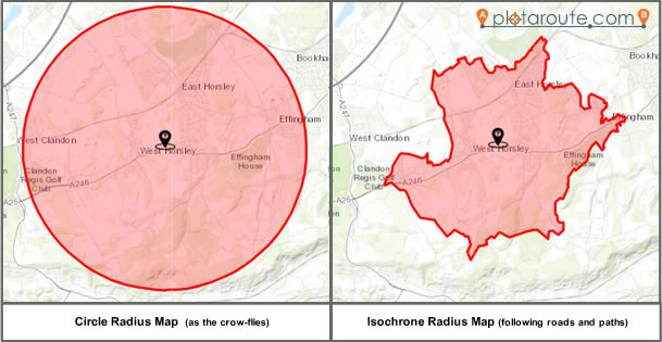
Using the new tool, you can see where you can reach from home (or any other point of origin) in a given time or distance. This can either be as the crow-flies or by following roads and paths. Plotting a radius map as the crow-flies will generate a circle around the point of origin. Plotting a radius map following roads and paths will generate an isochrone, based on the furthest points you can reach.
Once you've generated a radius map, you then have the option of adding it to the background map in the route planner, so that you can use it as a visual aid when planning your route.
You can access the new Plot a Radius Map tool from the toolbar in the route planner and from the navigation menus.
Due to the intensive processing necessary to generate radius maps, there are limits in place on the maximum time and distance you can set, but we will monitor and review these over time. Also, the tool is currrently only available on the desktop version of the website, but again, this is something we will review.
We hope you'll find the new tool useful and that it will help you to stay safe when going out to exercise.

- 1
