Posts for this topic...
-
Post your comments.... Sign In to Post
-
plotaroute admin Wednesday 22 Nov 2017 12:31:57
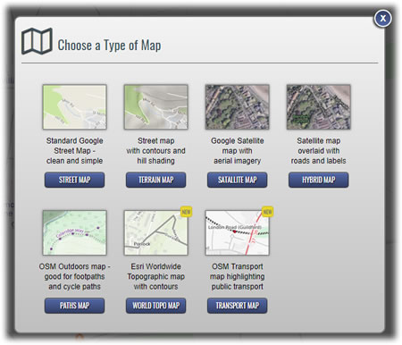
As part of our continued investment to make plotaroute.com the best online route planner, we have introduced two new types of map to choose from:
- World Topographic Map - This global map from GIS experts Esri includes boundaries, cities, water and physiographic features, parks, landmarks, transportation and buildings. Contour lines and hill shading add detail to a map that makes an excellent base on which to plan and showcase your routes.
- Transport Map - This map uses a custom design built on worldwide OpenStreetMap data, to highlight public transport links. Roads and paths are understated to give prominence to train and bus routes, including bus route numbers where available, making it very useful for planning routes away from home.
In addition to adding these two new types of map, we've also made it possible to share routes using any of the available map types, so you can now choose from seven different types of map when plotting and sharing your routes. We hope to add further options in the future.
Lastly, we've changed the default map from Google's Street Map to Google's Terrain Map, as this shows more clearly where those all important hills are!
- World Topographic Map - This global map from GIS experts Esri includes boundaries, cities, water and physiographic features, parks, landmarks, transportation and buildings. Contour lines and hill shading add detail to a map that makes an excellent base on which to plan and showcase your routes.
-
jan knoester Friday 24 Nov 2017 17:48:32
Wow great thanks
-
Roger Leary Thursday 04 Jan 2018 18:19:22
It would be nice if the user could choose a defult map setting as I prefer the basic google maps initially then later look at topo.
-
plotaroute admin Friday 05 Jan 2018 10:15:50
Thanks for the suggestion. Coincidentally someone else just suggested the same thing! I've added it to our Feature Requests list (number 77) - if anyone would like to see this added, please vote for it there.
John
-
John Wesley Brett Monday 21 Jun 2021 12:00:24
With the recent advent of being unable to print using World Topo maps, can we revisit the inclusion of OpenTopoMap in the printing options?
Thanks,
John.
-
plotaroute admin Tuesday 22 Jun 2021 07:47:14
Hi John - We don't have room our our current map servers for another map type but it's something we might be able to add in the future. You should still be able to be able to print with the World Top maps though or our Terrain map, which is also a topographic map with contours and hill shading.
- 1

