Posts for this topic...
-
Post your comments.... Sign In to Post
-
plotaroute admin Saturday 16 May 2015 08:16:08
Hi Earl - thanks for the suggestions. These are good ideas and it's very tempting to take the site in new directions like that but we're keen to keep the site focused and not diverisfy too much, as this would make it more complicated to use, so we don't plan to add features for tracking timings on a route at this stage, or any more route types. We've actually just recently added motorcycling and horse riding as new route types. We did consider rowing/canoeing as well but I thnk we probably won't add that unless we can also develop a faciliity to automatically calculate routes along waterways.
Thanks again for the suggestions.
John
-
Earl Hampton Friday 15 May 2015 18:34:14
Have you considered canoe or rowing as an option.
Also It would be nice to have a length of time the activity took field.
Another idea is similiar to the graph for elevations, would be a graph of speeds over the route.
Thanks
Earl
-
plotaroute admin Friday 08 May 2015 14:43:37
Hi Debbie - support for Horse Riding routes is coming very soon now. It's the next thing in the pipeline, so keep an eye out for an announcement on this.
John
-
Debbie Blenkiron Friday 08 May 2015 13:49:16
Hi, would be fantastic to include Horse riding!!
-
David Tidmarsh Friday 03 Apr 2015 07:10:19
I have tried the new features as part of the proposal to extend the site to include horse riding. Excellent, John. In particular Combine routes. This enhances the horse trail riding in an area (e.g. Cairngorms) or over several days where there are mutiple routes (sections) that can be combined in different ways to make a up a unique route of choice. It also helps with plotting / saving shorter sections that can then be combined by a user to make a longer horse ride. Thanks indeed John.
-
plotaroute admin Tuesday 24 Mar 2015 09:23:35
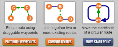
We're excited to tell you about 3 great new features that we've just added to our route planner:

PLOT WITH WAYPOINTS -This feature lets you plot an extensive route by adding just a handful of waypoints to the map. You can drag the waypoints around to easily change the route until you are happy with it, making this a fantastic option for quickly experimenting with ideas for new routes.
COMBINE ROUTES - Use this new feature to join together nearby routes into a single longer route. You can combine any public routes on the database that are in the area - the route planner will automatically connect them provided they are close enough to each other.
MOVE START POINT - This feature is for use with circular routes and enables you to move the start/finish to a different point along the route by simply dragging a marker on the map.
All of these new features can be found under the Plot menu in the route planner. As always, our focus has been on adding new features that are intuitive to use and help to make route planning easy. We hope you'll find these latest enhancements useful.
- 1

