CREATE FREE ROUTE MAPS FOR YOUR EVENTS
Fully interactive custom route maps
with elevation profiles and download options
Easy to create using our simple route planner
or upload the route from a GPS file
FEATURES AND BENEFITS
Create and share custom routes maps using plotaroute.com for free
FOR EVENT PARTICIPANTS
- Unique animated route maps
- Full-screen interactive maps
- Choice of map types
- Elevation profiles
- Wide range of download options
- PDF print out of map and directions
- Completion time estimates
- Calorie calculator
- Weather forecast
- View map on mobile or desktop
FOR EVENT ORGANISERS
- Share route map with simple link
- QR code for use in leaflets and online
- Embed the map on your website
- Get images of route map and hill profile
- Add labels to route map (e.g. water, registration)
- Show different routes on one map
- Share photos with your route map
- Reuse route map for repeated events
- Route available on our route finder
- Share your route map for FREE!
FAR MORE THAN JUST A MAP
Give your event participants more
with our detailed route profiles and statistics
SMARTER MAPS
Bring your maps alive!
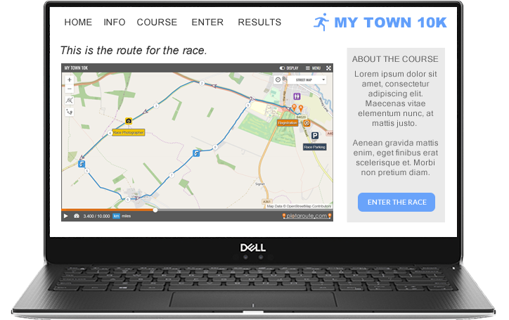
Our animated route maps are a unique feature of plotaroute.com, providing resizable interactive maps that can be displayed on any website or blog, much like a YouTube video. The animation brings the map alive, making it easy to see the path a route takes, even where there are repeated loops or out-and-back sections. We think this is a really effective way to visualise a route.
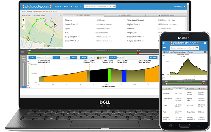
And our maps are smart too! You can find out the distance, elevation, gradient and estimated arrival time for any point on the route. You can also highlight all the uphill and downhill sections in red or green, so that you can see them on the map, as well as displaying a conventional elevation profile. We even make the route see-through when you touch the map, so that you can read the road names underneath it.
Need to add your own touches? Maps often need embellishing, so with our maps you can add custom labels and symbols, photos, swappable detours to show shortcuts and extensions, and your own additional directions or notes.
We offer a wide range of formats for printing and downloading routes, but what is even better is that you can navigate the route with turn-by-turn directions all from the same smart map.
GET AN INTERACTIVE MAP FOR YOUR EVENT NOW
DESKTOP TABLET MOBILE
